Royce Geo SPEAR Capability Featured in Space News Article
In Navy experiment, commercial satellites serve as key weapons against drug traffickers
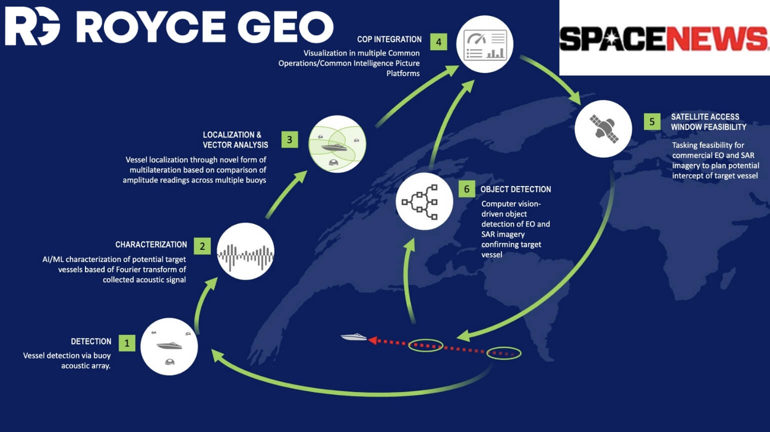
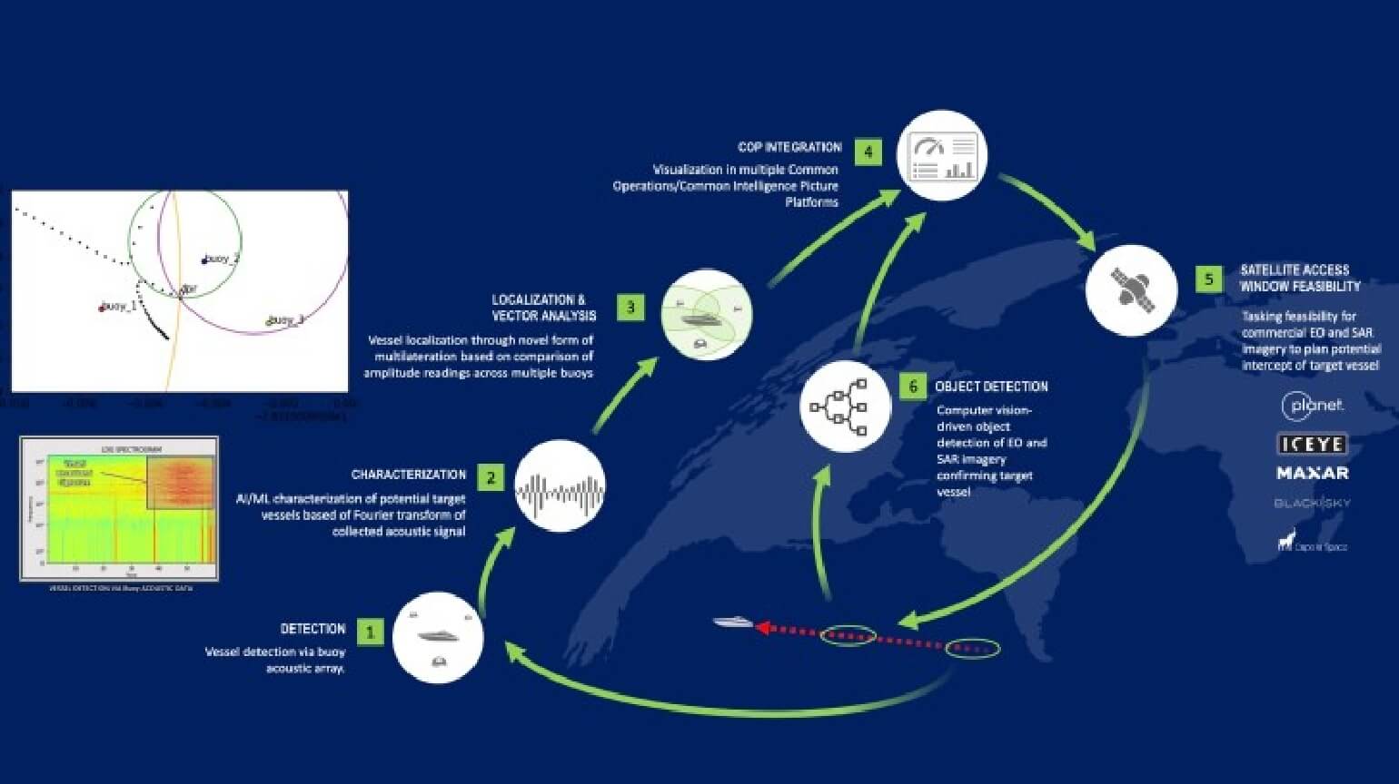
Friday April 14th, Space News released an article featuring Royce Geo’s SPEAR capability, which deploys CURVE OE to the tactical edge using open water buoys with acoustic sensors. This capability is enabling Royce Geo to work with the US Navy to experiment with utilizing commercial satellite imaging sources to track potential drug running vessels as part of the SCOUT Exercises, as well as serving other projects for the US Navy and US Army.
Full Space News article HERE
Reposted here:
WASHINGTON — In an experiment last fall near Virginia’s coast, a team of engineers used commercial hardware, software and satellite data to show the U.S. Navy how it could quickly turn information from satellites into useful intelligence.
The Office of Naval Research sponsored the experiment to identify readily available technologies that could help U.S. Southern Command to detect and identify illegal drug-trafficking boats that turn off their lights at night and do not emit radio signals.
Royce Geospatial Consultants, a geospatial data analytics company, pitched the Navy the idea of using floating acoustic sensors to tip and cue imaging satellites.
It deployed a network of acoustic sensors on small buoys that detected noise signatures off drug running vessels. The vessels’ tracks were sent via Iridium satellite links to the company’s AI platform that automates satellite imagery collection based on what assets are available at the time they’re needed. For the Navy experiment, it tasked Planet’s electro-optical and Iceye synthetic aperture radar (SAR) satellites to capture images of the moving vessels.
Using imagery analytics software, Royce Geo identified the location of the vessels and sent these reports to the Navy’s command center, the company’s CEO Dave Sterling said in an interview.
“The total time from acoustic detection to vessel report was about 30 minutes,” Sterling said.
He noted that naval units at Southern Command rely on a limited supply of maritime patrol aircraft to chase narcotraffickers, and want to take advantage of commercial Earth monitoring satellites and artificial intelligence to do this job more efficiently.
There are increasingly more commercial Earth observation satellites so the tipping and cueing are critical to make the best use of these assets, Sterling said. Military commanders, he said, want to leverage this technology to track and monitor fast moving objects.
Navy to continue experiments
The Office of Naval Research said the vessel-identification experiment is one of many that are being funded to “solve warfighter problems … and ultimately help protect the United States from illicit drug trafficking.”
Sterling said Royce Geo won a contract from the Naval Surface Warfare Center to continue these experiments into next year in support of the Navy’s Joint Interagency Task Force South which is responsible for interdiction of illicit trafficking.
The company is working with other customers in the U.S. Navy and U.S. Army that are looking for ways to exploit commercial sources of intelligence but don’t always know how, Sterling said.
“The problem is that you have a tremendous amount of information that you have to parse through from the commercial space layer to really figure out what is possible in terms of getting after your targets if you’re a military commander.”
“If I’m chasing a target, what assets are truly in the area that I can effectively get after?” Sterling added. That is a question many military leaders want answered.